

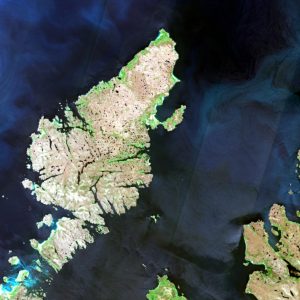
Outer Hebrides in Scotland. Image acquired by Sentinel-2B on the 28th June 2019.
Image courtesy of ESA/Copernicus.
Land reclamation is the concept of creating or restoring land, where none currently exists. It’s usually done in waterlogged coastal areas, using materials such as rocks, soil, and sand that are built up until they are higher than the sea level. Alternatively, land can also be created by pumping out the water within an area, although the danger here is that the reclaimed land is still liable to flood.
Almost 17% of The Netherlands has been reclaimed and the world’s largest reclaimed island, at 970 sq km, is Flevopolder in Flevoland. The eastern area was reclaimed in 1955 and the southern area in 1968.
Singapore’s first recorded land reclamation was in 1819 when mangrove swamps and villages were cleared by Sir Stamford Raffles to create trading posts. However, it was not until 1965 that they really started land reclamation in earnest. Since then, the country has seen it’s land size increase by a quarter from various land reclamation projects including for residential, tourist and industrial uses. It’s not finished yet either, with plans for further work up until 2030. Other well known land reclamation projects include Dubai’s Palm Island and other islands, which we’ve written about before, Kai Tak Airport in Hong Kong, the Saemangeum land reclamation project in South Korea converting around 600 miles of coastal wetlands, parts of Nice Airport in France were reclaimed from the sea and a significant proportion of Monaco.
However, land reclamation has been going on a longer than that, in fact, a lot longer than people thought! Crannogs are artificial islands that are widespread within Scottish and Irish water bodies and were thought to have been built in the 9th Century in Scotland’s Outer Hebrides. However, a paper published last week in the Antiquity Journal suggests that they are 3,000 years older than that.
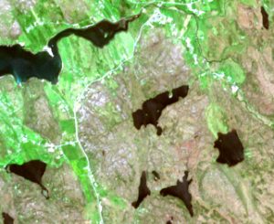
Zoomed image showing some of the lochs on the Outer Hebrides, and the crannogs within them. Image acquired by Sentinel-2B on the 28th June 2019.
Image courtesy of ESA/Copernicus.
The paper entitled ‘Neolithic crannogs: rethinking settlement, monumentality and deposition in the Outer Hebrides and beyond’ by Garrow and Sturt, describes research that has demonstrated for the first time several of the Outer Hebridean crannogs were built between 3640–3360 BC, and they could have been more common in the Neolithic period than we believed as only 20 percent of Scotland’s crannogs have been scientifically dated in this way.
The researches noted that the crannogs were created by piling up rocks in the waterway, and they have a flat central area, but it is not known what their use was. However, they discovered a large number of pottery and ancient timbers in the water surrounding them. The researchers believe that they could have been used for feasts or other religious or social rituals as they are in isolated areas. Some crannogs can be seen in the zoomed-in image above – admittedly you may have to look closely, but they are there! There are two in the central body of water, and one in the one to the right.
The mystery deepens given the sheer size and weight of the crannogs, with the team identifying one that measures 26 m by 22 m and it’s estimated that the rocks required to create it weighed around 240 kg each!
This shows that there is still a lot to discover about the world, and unlike Palm Island we can’t use Earth Observation to track their building, but there is still a lot we can explore from space!
