

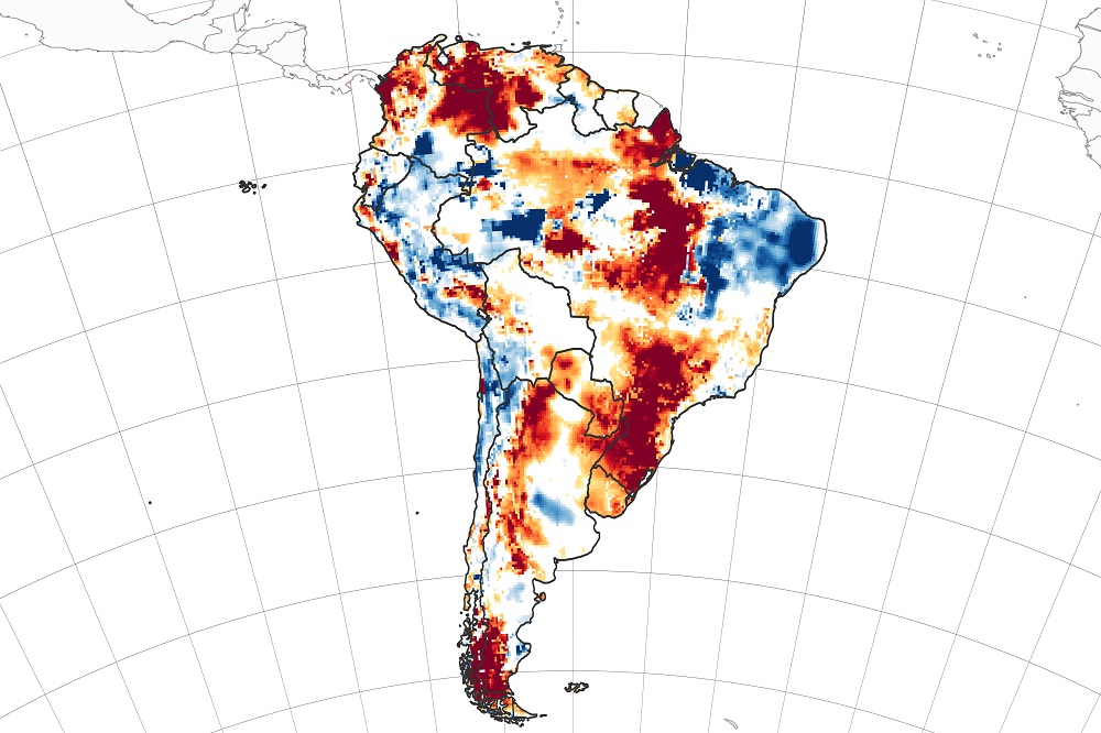
Root Zone Soil Moisture for South America on 30th March 2020. Data courtesy of NASA/NASA Earth Observatory with images by Joshua Stevens, using GRACE-FO data from the National Drought Mitigation Centre.
Two reports caught our attention this week as they have links to some of the work we’re doing on a couple of UK Space Agency International Partnership Programme (IPP) projects. The first was from NASA Earth Observatory looking at drought conditions in South America, and the second was from ESA on the Arctic Ozone hole.
Researchers from the NASA Earth Observatory and the US National Drought Mitigation Centre have used data from the Gravity Recovery and Climate Experiment Follow-on (GRACE-FO) mission to produce maps of South America highlighting areas on that continent which are facing rainfall deficits and potentially droughts.
Parts of Argentina, Brazil, Chile, Colombia and Venezuela all reported rainfall deficits and drought conditions in February and March this year, combined with excessive heat. The continent has had its second warmest December to February period for over a century. The image at the top of the blog shows root zone soil moisture across the area, and the image below is for shallow groundwater storage. Both images are as of March 30, 2020, where the blue areas show more wetness than expected, whereas the orange and red areas are where there is less wetness than usual.
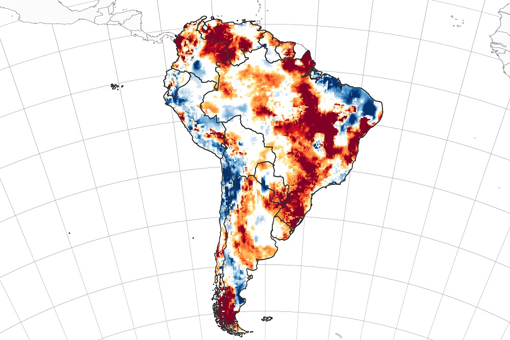
Shallow groundwater storage for South America on 30th March 2020. Data courtesy of NASA/NASA Earth Observatory with images by Joshua Stevens, using GRACE-FO data from the National Drought Mitigation Centre.
The data has been produced by GRACE-FO mission, which is a twin satellite constellation flying in a low Earth orbit at 490 km. Launched in 2018 it is a joint mission between NASA and the German Research Centre for Geosciences. These twin satellites constantly measure how far apart the two satellites are by sending microwave signals between themselves. This distance changes under the influence of the Earth’s gravity, by pulling the lead satellite away from its partner. Precisely measuring this, makes it possible to map the changes in the Earth’s gravitation field. The key instruments onboard them are:
- Microwave Instrument (MWI): this sends K and Ka band microwave signals between the two satellites to precisely measure their distance apart. It is reported that they are accurate to one micron.
- Laser ranging interferometer (LRI): This experimental instrument is an addition to the original GRACE mission and makes the same measurement as the MWI, but using lasers instead.
- Accelerometer: Measures the factors other than gravity affecting the satellite orbits.
The team behind these satellites have just started releasing online weekly global maps of groundwater and soil moisture, distributed by the National Drought Mitigation Centre at the University of Nebraska-Lincoln (UNL). At Pixalytics we’re interested as we have our own soil moisture product, currently being used in the Drought & Flood Mitigation Service (DFMS) IPP project in Uganda, which is led by RHEATECH. We’re also looking to implement it across parts of Colombia as part of a second IPP Project, the Ecological Productivity Management Information System (EcoProMIS) led by AgricCompas. We also run it daily across the UK. Soil moisture measurements help to determine how much water is available to plants, which is critical for agriculture.
The second report was produced by researchers from German Aerospace Centre (DLR) who have identified a significant depletion of ozone over the northern polar regions using data from the Tropomi instrument onboard Sentinel-5P.
A hole in the ozone over Antarctica usually occurs every autumn, but this research indicates that there has been a depletion of ozone over the Arctic and they’ve noticed freezing temperatures in the stratosphere due to a polar vortex – a circling whirlpool of stratospheric winds – that has trapped cold air and so when the polar winter ended sunlight caused the hole to form.
This Arctic hole is very much smaller than the Antarctic one, and although it is the biggest hole over this area for a quarter of a century the scientists expect the hole to close again during this month.
Although we are not measuring ozone, we are currently working with Sentinel-5P data to look at trace gases to try and understand sustainable farming’s impact on greenhouse gas emissions for the EcoProMIS project.
Both of these reports have given us things to think about whilst we are all working from home!
