

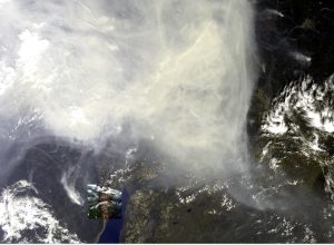
Sentinel-3B image of northern Siberia showing the smoke from the Arctic Fires. Image acquired on 27/07/19.
Image courtesy of ESA/Copernicus.
The Arctic currently has hundreds of wildfires stretching across northern Russia, northern Scandinavia, Alaska and Greenland. It’s strange to think that one of the coldest places on the planet is on fire, but it is!
Fires are not unusual in the Arctic and are often considered part of the ecosystem, burning old vegetation to make way for new shoots. However, the Arctic is currently warming much faster than the rest of the planet, meaning that as the ice melts huge areas of vegetation are being exposed to sunlight the for the first time giving additional fuel for the blazes.
These fires are often triggered by lightning, but what’s different this year is the number of fires, the large area they cover and their intensity. The Copernicus Atmosphere Monitoring Service tracks the fire using Sentinel data, plus data from MODIS on both Terra and Aqua satellites, within its Global Fire Assimilation System. It has seen over 100 intense and long-lived wildfires within the Arctic Circle in the last two months, and in Alaska, it has seen almost 400 wildfires this year with new ones starting every day. It estimated that the current total area involved is almost eight million acres. Yesterday, Russia declared a state of emergency over wildfires in the Krasnoyarsk Krai and the Irkutsk regions of Siberia, with fire continuing to spread East.
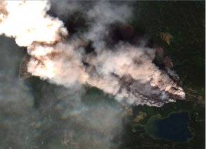
Sentinel-2B image of northern Siberia showing one of the Arctic Fires. Image acquired on 27/07/19.
Image courtesy of ESA/Copernicus.
The Sentinel-3 image at the top of the blog shows an area of northern Siberia with the large plume of smoke rising from it. Just below the left of centre is a small square showing a Sentinel-2 image of a specific area. A larger version of a portion of the Sentinel-2 image can be seen on the left. It is just one of the fires that have been identified and the ferocity of the blaze can be seen from the smoke billowing up from the land.
The fires themselves are not the only issue, they are also destroying permafrost as they burn through the tundra and in turn, some of the peatlands beneath the vegetation have also caught fire. This thawed, dried, peat is releasing significant amounts of carbon dioxide (CO2) into the atmosphere.
To give a context, the fires with the Arctic Circle released 50 megatonnes of CO2 into the atmosphere in June only, which is more than was released by Arctic fires in the same month between 2010 and 2018 put together, and it’s also equivalent to Sweden’s total annual emissions.

Visualisation of Aerosol index data from Sentinel-5P across northern Siberia. Data acquired on 27/07/19.
Data courtesy of ESA/Copernicus.
The image to the left is from Sentinel-5P and shows the aerosols index over the area. The lake in the bottom right-hand corner is the same lake that can be seen at the bottom of the Sentinel-3 image. The impact of these fires is very clear.
Finally, to complete the vicious circle of these fires, the particulate matter settles on icy areas darkening that ice, leading to sunlight being absorbed rather than reflected, which could add to the warming effect.
This is a huge issue for the planet and needs to be monitored. Due to the vast area involved satellites are the best, and perhaps only, tools that can be used. The combination of the various Copernicus Sentinel, and NASA, satellites as shown here provides us with a holistic view of what is happening.
