

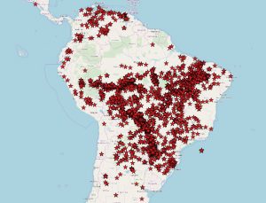
Active Fires in South America during 24 hour period of the 23rd August 2019. Data and imagery courtesy of LANCE FIRMS operated by NASA’s Earth Science Data and Information System (ESDIS) with funding provided by NASA Headquarters. The image also uses © OpenStreetMap contributors under licence.
Earlier this month the Copernicus Climate Change Service issued its July report, which showed that every month during 2019 has ranked within the top four warmest on record for that particular month.
In June European average temperatures were the warmest ever recorded, more than two degrees above normal. It was also the second warmest July on record falling just short of the 2016 record. In addition, July was very close to 1.2C above the pre-industrial temperature target in the 2015 Paris Agreement that aimed to ensure global temperatures did not rise two degrees above this level and tried to ensure it remained within 1.5 degrees.
Despite the notorious British weather, last month the UK recorded its hottest ever temperature of 38.7C at the Cambridge Botanical Gardens. This weekend has also seen the warmest August Bank Holiday on record, with Sunday and Bank Holiday Monday recording temperatures of 33.3C and 33.2C respectively.
The July Copernicus Climate report also highlighted:
- Holland and Belgium also had their highest ever temperatures, with both exceeding 40C for the first time. Germany also had its hottest day, recording 42.6C in Lingen; and the heat extended north into Scandinavian countries with both Finland and Norway seeing temperatures over 33C.
- High temperatures were also seen over Alaska, Greenland, parts of Siberia and large parts of Antarctica.
- The extent of sea-ice in both Polar Regions was lower compared to the average figures between 1981 and 2010 – the Arctic itself was around 23% lower.
As well as higher temperatures and sea-ice reduction in the Arctic, it has also been suffering from a significant increase in wildfires; as we’ve previously written about. Wildfires, as we’re sure you will have seen on the news, are also currently raging in the Amazon. 2019 is the most active fire year for a decade, with 74,000 fires being recorded this year that is an 84% increase on 2018.
Scientists are particularly concerned about the current position as normally drought is a key factor in the fires, whereas this year it’s thought that land clearing is playing a much larger role. The Amazon is known as a key part of the Earth’s ecosystem, and these fires are likely to cause a more intense dry season in South America, according to comments by Yadvinder Malhi, Professor of Ecosystem Science at the University of Oxford, in an interview with the BBC; and it will take the Amazon forest around twenty to forty years to regenerate.
With the large scale nature of these fires, satellites are ideally placed to do the monitoring. NASA uses its Moderate Resolution Imaging Spectroradiometer (MODIS) instrument, which is onboard both the Aqua and Terra satellites, together with the Visible Infrared Imaging Radiometer Suite (VIIRS) on Suomi NPP to monitor fires from space.
The image at the top of the blog is the fires recorded in the 24 hour period for of the 23rd August from the MODIS product at one square kilometre resolution, which shows a whole series of fire detections across Brazil. It’s important to note that this is not the number of fires detected, but pixels where fires have been detected within the one square kilometre area. Therefore, large single fires may stretch over several kilometres and be recorded in several pixels, and equally, there may be multiple small fires within the same area which only show up as one pixel.
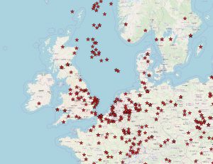
Active Fires in Europe during 24 hour period of the 23rd August 2019. Data and imagery courtesy of LANCE FIRMS operated by NASA’s Earth Science Data and Information System (ESDIS) with funding provided by NASA Headquarters. The image also uses © OpenStreetMap contributors under licence.
This data is freely available from NASA through its Fire Information for Resource Management System (FIRMS) website. It’s also interesting to note this provides global coverage, and the image below is Europe using the VIIRS product which is at 375m resolution. There are a number of fires detected across various countries, including the UK and one quite close to Pixalytics down in the South West. Finally, the fires in the North Sea on this image will relate to oil rigs.
There is a lot happening in the world’s climate at the moment, and satellites are part of the key tools for monitoring what is happening now and how it changes over time.
