

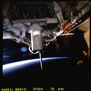
Lidar In-space Technology Experiment aboard STS-64. (Astronaut Photograph). Image courtesy of the Earth Science and Remote Sensing Unit, NASA Johnson Space Center.
Last month was the 25th Anniversary of LITE – the Lidar In-space Technology Experiment (LITE) that was the principal payload on the Discovery Space shuttle mission STS-64, which took place between the 9th and 20th of September 1994. Whilst you might not have heard of LITE, its impact on Lidar missions for Earth Observation cannot be underestimated. It was a three-wavelength backscatter lidar mission that proved an Earth-observing lidar could work in space.
The Laser Transmitter Module emitted light wavelengths of 1064 nm (infrared), 532 nm (visible green), and 355 nm (ultraviolet) for the 53 hours that it operated. The returned images were captured on a modified 35 mm camera with a 25 mm focal length to give a spatial resolution of 200 x 200 km for each image, and there was approximately 21 seconds between each picture giving around twenty percent overlap between the images. Each image had a GMT timestamp allowing the latitude and longitude for the centre of each frame to be determined.
During the mission over 40 gigabytes of data was collected revealing three-dimensional views of the aerosol and cloud structure of the atmosphere. Following this proof of concept, there have been a series of missions that have followed including:
- Cloud-Aerosol Lidar and Infrared Pathfinder Satellite Observation (CALIPSO), a joint satellite mission between NASA and the French space agency (CNES) that launched in 2006 and is part of the infamous A-Train!
- Ice, Cloud and land Elevation satellites (ICESat and ICESat-2)
- Atmospheric Dynamics Mission Aeolus (ADM-Aeolus) from ESA
- Global Ecosystem Dynamics Investigation (GEDI)
- Cloud-Aerosol Transport Systems (CATS)
So whilst we celebrate all the exciting data that we collect today we should remember that its collected stood on the shoulders of missions like LITE.
Moving to the present, China launched the Gaofen-10 satellite, via the Long March 4C rocket, last Friday 4th October at 1850 GMT from the Taiyuan Satellite Launch Centre in Shanxi Province in China. The satellite went into a polar orbit at an altitude of just over 600 kilometres and will be part of the China High-resolution Earth Observation System (CHEOS) and is believed to be a replacement for the Goafen-10 satellite that was lost during a launch failure on 31 August 2016 – although this has not been confirmed by the Chinese state media. Gaofen-10 is reported to be a high-resolution Earth Observation satellite with a sub-metre resolution microwave sensor, and is expected to be used in applications such as land surveying, urban and infrastructure planning, crop yield estimates, and disaster support.
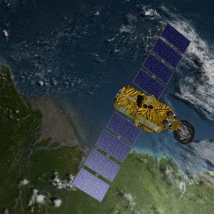
Artist rendering of Jason-3 satellite over the Amazon.
Image Courtesy NASA/JPL-Caltech.
As a new satellite is born, we also have to report the sad demise of another. On the 1st October the Jason-2/Ocean Surface Topography Mission (OSTM) ended its mission. This was a joint mission between NASA, French space agency Centre National d’Etudes Spatiales (CNES), NOAA and EUMETSAT was launched in 2008, however the partners agreed to end the mission after detecting deterioration in the spacecraft’s power system. It’s successor Jason-3 is already in orbit, having been launched three years ago.
Finally, into the future! It was announced last week that ESA had selected the Far-infrared Outgoing Radiation Understanding and Monitoring (FORUM) satellite as their ninth Earth Explorer mission, with a planned launch date of around 2026.
The mission, with a budget of €260 m, will carry a spectrometer to sense the far-infrared radiation coming up off the Earth which will provide further understanding of climate change as it’s in this part of the electromagnetic spectrum is strongly impacted by water vapour and ice clouds, which are potentially key elements of planet warming.
The EO industry, like all others, should never forget where it came from it helps us understand where we are going.
