

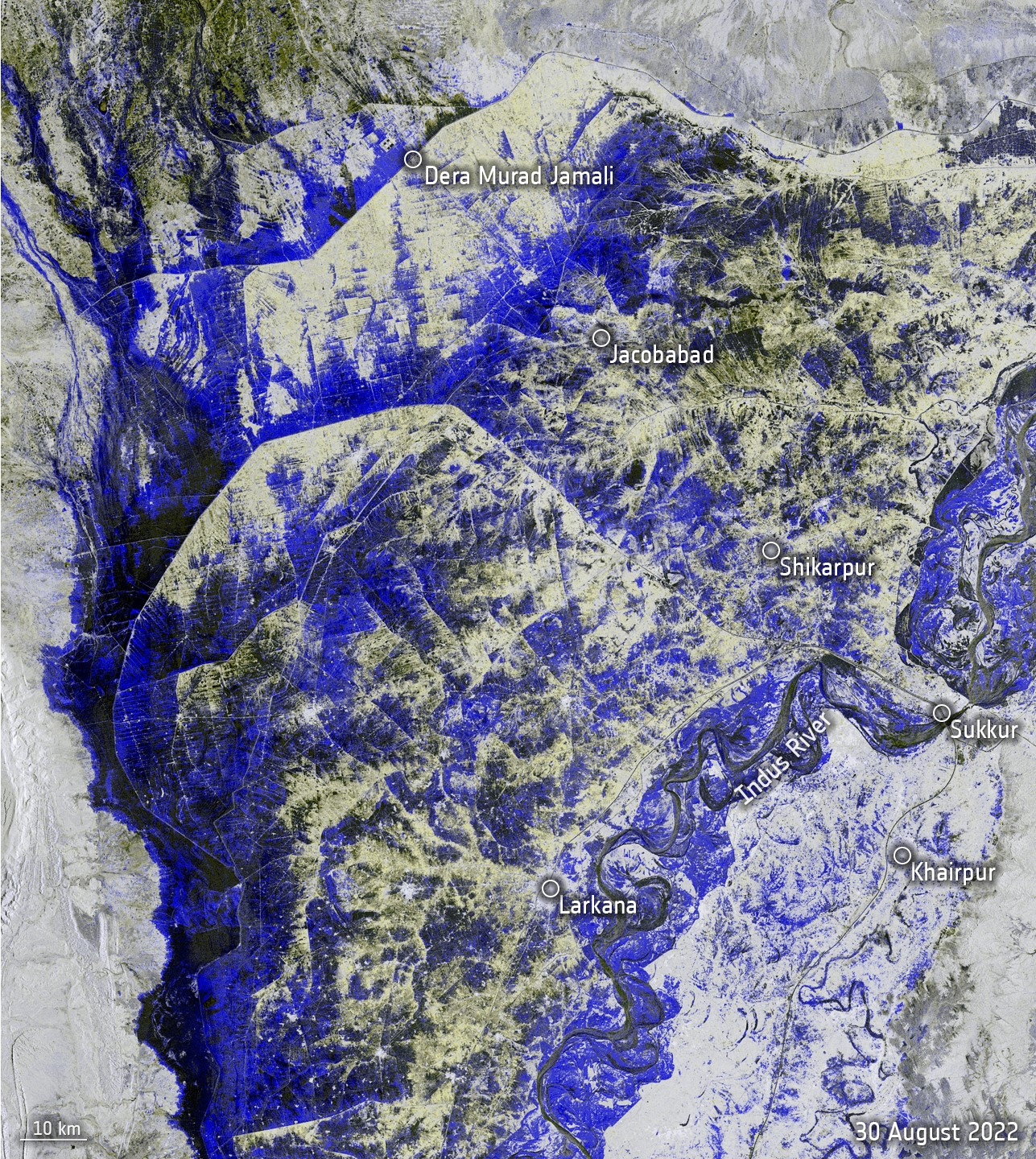
Pakistan floods showing the area between Dera Murad Jamali and Larkana. The blue to black colours show where the land is submerged. Data courtesy Copernicus/EA, image contains modified Copernicus Sentinel data (2022), processed by ESA, CC BY-SA 3.0 IGO
Water has constantly been in the headlines over the last few months. In northern Europe there has been a scarcity of water and concerns about drought, although the rains are starting to arrive. Compare this with Pakistan that has suffered horrendous flooding with the image to left acquired by Sentinel-1 on the 30th August 2022, showing how the Indus River has overflowed, creating a long lake, tens of kilometres wide and overall much of the country is currently underwater, it is reported that almost one third of the land is submerged with over a thousand people having lost their lives and tens of millions impacted by this disaster. Currently, authorities in Pakistan are fighting to prevent their biggest lake, Machar Lake, from bursting its banks.
Flood Water In America
Over in America there has been flash flooding in the south west with Georgia and Mississippi both suffering. Deanne Criswell, Director of the Federal Emergency Management Agency (FEMA) said last week that the flood maps used by the federal government were outdated, as they did not take into the account the large rainfall that is occurring due to climate change. This rainfall is altering the areas of concern for flooding, and will require further development and refinement of predictive flooding models to support warning and monitoring systems. Clearly, satellite data can be a key part in supporting these developments.
India Water Solution for Gujarat
This week also saw reports of how India has used satellite data to help plan, and deliver, a water resources solution for the state of Gujarat. The state has five regions and three were very water deprived, with one only having two percent of their own water resources. In 2003, the Bhaskaracharya National Institute for Space Applications and Geo-informatics (BISAG) began wotrk to look at this issue. Details of all the water bodies within Gujarat were obtained using high-resolution Indian satellites, and these were combined with other datasets including soli type, land use, terrain models, forests, road and rail networks, etc. All of the data was then visualised in a GIS together various other land survey datasets, and this was then used to develop a variety of proposals for the new water infrastructure. The solution includes:
- Increasing check dams – a traditional method to recharge groundwater – from 6,000 in 2002 to 166,000 in 2016 holding approximately 28,500 million cubic feet of water.
- Developing the canal network with improvements to Narmada Main Canal, Sujalam Sufalam Yojana and SAUNI Yojana. This was not simply developing the canals, but also was underpinned with various pipelines, irrigation pipelines and sub-canals to ensure water can get to areas that need it.
Indian Prime Minister Narendra Modi recently opened the Kutch Branch Canal, one of the final pieces of the project, and this means it is able to bring water from 750 km away. This project is now being seen as a trail blazer, and the intention is that a lot of future projects will be led by satellite observations. The first step is to map the entire country from satellite and then combine with various administrative datasets. This pool of data will be used to plan infrastructure projects to help efficiency. It is certainly an interesting and innovative way of getting benefit from satellite and GIS data.
Conclusion
Satellites can play an increasing useful role in planning, delivering and monitoring water resources and associated infrastructure projects. However, as the Director of FEMA indicated, it is important that plans, maps and areas of vulnerability are updated in accordance with the changing climate.
