

Following on from our previous blogs discussing the use of Artificial Intelligence (AI) for Earth observation, this week’s blog focuses on its use for monitoring the Arctic.
The extent of Arctic sea-ice cover has declined for the entire period that satellites have been monitoring it – more than 40 years – with an average loss of 13% per decade. This sea-ice extent depends on whether the winds have spread out the floes or pushed them together, with thickness providing vital information. Satellites can measure thickness using altimetry, a process where a microwave signal is sent out and received back. The time of the return signal tells the operator the distance, with the difference in the height of the water and sea-ice providing information on sea-ice thickness.
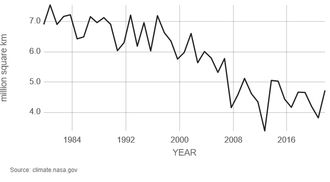
Annual minimum Artic sea-ice extent measured during September using satellites. Credit: NSIDC/NASA
The European Space Agency’s CryoSat-2 mission carries an instrument to measure this height difference. AI is used to help the algorithm learn and identify reliable observations from a vast library of synthetic radar signals. Thanks to this new approach, the University College London (UCL) team has been able to go back through the records to recover full-year ice thickness measurements for the entire time series.
The approach is now also being applied to NASA’s ICESat-2 laser altimetry data – uses an optical laser rather than a microwave signal as used by CryoSat-2 but the same approach of measuring the return time and hence distance. CryoSat-2 and ICESat-2 are also being used together over Antarctica, with ESA periodically raising the orbit of CryoSat-2 to align with ICESat-2. The aims are to reduce inaccuracies in sea-ice and land-ice measurements, map snow at the poles and improve climate models.
