

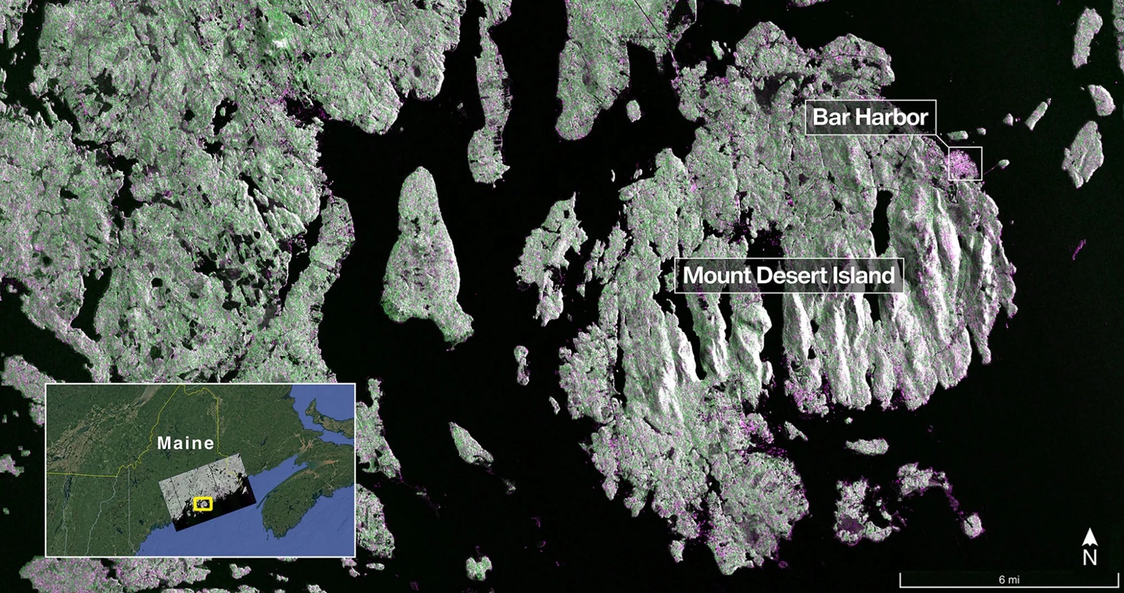
Image from NISAR’s L-band SAR on 21 August 2025 shows Maine’s Mount Desert Island. Image Credit: NASA/JPL-Caltech
This week we look at the first light images form the NISAR satellite, the latest Earth Observation (EO) launches from China, and the slightly bizarre trend of satellites taking pictures of each other!
NISAR First Light Images
The first images from the NISAR (NASA-ISRO Synthetic Aperture Radar) satellite have been released. This joint mission between NASA and the Indian Space Research Organisation was launched on the 30th July and we discussed it in an earlier blog; the key feature is that it has both L-band and S-band synthetic aperture radar (SAR) instruments onboard, operating at different frequencies.
The first two images released have been acquired by the L-Band SAR, and these were:
- Mount Desert Island on the Maine coast as seen at the top of the blog was acquired on the 21st August, where the green indicates forests and magenta represents bare ground and buildings; the magenta colour in the northeast is the town of Bar Harbor.
- North Dakota’s Forest River image, shown below, was acquired on the 23rd August and focuses on agriculture, with the darker areas showing fallow fields, and the lighter colours indicating pasture or crops. The circular patterns are telltale signs of the use of centre point irrigation, where sprinklers rotate around a central point.

NISAR image from the L-Band SAR of North Dakota’s Forest River area from the 23rd August 2025. Image Credit: NASA/JPL-Caltech
These images show L-Band’s ability to distinguish different land types, and it will be exciting to see what the S-Band instrument will show in the future.
Chinese Satellite Launches
On Saturday, 26th September, China launched the Fengyun-3 08 satellite into a sun-synchronous orbit via a Long March-4C rocket from the Jiuquan Satellite Launch Center. Developed by the Shanghai Academy of Spaceflight Technology, Fengyun-3 08 is a meteorological satellite and has nine remote sensing instruments onboard including a medium-resolution spectral imager, an infrared hyperspectral atmospheric detector and a microwave imager allowing for high-precision global greenhouse gas detection.
It forms a three-satellite constellation with two other Fengyun satellites that together offer global coverage. The data will be used for applications such as weather forecasting, atmospheric chemistry and climate change monitoring, and it is reported that it will allow weather forecasting models to produce predictions every 4 hours, rather than the current 6 hours; and should enable forecasters to extend weather forecasts by a day.
Two days later, China also successfully launched Shiyan-30 01 and 02 satellites aboard a Long March-2D carrier rocket from the Xichang Satellite Launch Centre. The satellites are reported as have a primary use of verification of experimental EO technologies – although the precise nature of the role is not known at present.
Satellite Photograph Wars
A new interesting tit-for-tit battle has broken out between the United States and China, but this time it is about photographing each other’s satellites.
It began in July, when the US company Maxar published high-resolution images of China’s Shi Jian-26 satellite (also known as SJ 26), taken by their WorldView Legion satellite. Shi Jian-26 was developed by the Chinese Harbin Institute of Technology and launched on the 29th May 2025. It is believed to be an experimental optical remote sensing satellite, potentially testing new technologies. The main image was estimated to have been acquired at around thirty kilometres, and offered a resolution of 1.9 centimetres per pixel, a second image was taken at a greater distance and lower resolution.
In response, on the 13th September, the Chinese Chang Guang Satellite Technology Company (CGST), a spinoff of the state-owned Chinese Academy of Sciences, published images of a Maxar Worldview Legion 2 satellite. These images were taken by CGST’s Jilin-1 remote sensing constellation satellites over time on the 8th September at distances between 40 to 55 kilometres.
Summary
It is always exciting to see the first light image of a new satellite, and NISAR is no different. China carries on the expansion of its EO fleet, and it is interesting to see satellites photographing each other and whether scientists would be able to ascertain any new knowledge of technologies each are using – it does make you wonder how many more of these sorts of pictures we will see in the coming months and years.
